 基于地图代数距离变换的空间实体分布的聚集度分析

《基于地图代数距离变换的空间实体分布的聚集度分析》由会员分享,可在线阅读,更多相关《基于地图代数距离变换的空间实体分布的聚集度分析(3页珍藏版)》请在装配图网上搜索。
1、第 31 卷第 2 期2006 年 3 月测绘科学Science of Surveying and MappingVol131 No12Mar12006基于地图代数距离变换的空间实体分布的聚集度分析耿协鹏 , 杨传勇 , 胡鹏(武汉大学资源与环境科学学院 , 湖北 武汉 430079)【摘 要】聚集度是重要的空间分析指标 , 但传统的聚集度计算方法存在适用范围小 、计算不准确的缺点 , 在介绍了地图代数距离变换的算法基础上 , 提出了空间全形态实体的聚集度计算方法 , 最后以北京周围两种旅游景点的空间分布的聚集度分析为实证 , 说明此方法是合理的 。【关键词】聚集度 ; 地图代数 ; 距离变换
2、【中图分类号】P28【文献标识码】A【文章编号】1009 - 2307 (2006) 02 - 0086 - 02为 1 (同时也是最邻近距离) , 如果按照式 1 计算 , 其聚集指数与图 1 (a) 中是一模一样的 , 很显然这是很荒谬的 。3地图代数的距离变换311 栅格平方平面基于栅格空间的空间分析具有数据结构简单 、容易向高1引言聚集度指 数 是 对 空 间 地 理 实 体 一 种 最 常 用 测 度 指 标 , 反映了空间实体空间分布的集中程度 , 被广泛应用到城市 土地利用 、服务设施布局 、城市体系结构的描述 。是空间 个体关联度程度大小的重要体现 , 它是衡量个体在空间上 纵
3、向排列所产生屏蔽效应 、竞争效应等空间作用大小程度 的重要指标 。对空间实体聚集度指数分析具有非常重要的意义 。例 如对城市土地聚集度进行分析可以说明城市各种土地开发 、 利用的精细程度 , 城市中某种行业工厂分布的聚集度分析 可以帮助了解该行业的发展阶段 , 而旅游景点的聚集度分 析是进行旅游区域布局的重要依据 。传统的聚集度分析是基于实体间最邻近距离来计算的 ,这种方法具有简单 、易操作的特点 , 但这种方法是非常粗糙的 , 为此本文提出基于栅格距离变换的计算方法来全面度量空间实体的邻近关系 , 从而使聚集度计算更加准确 。2聚集度指数常用计算方法及其存在的问题211 聚集度指数的定义及其
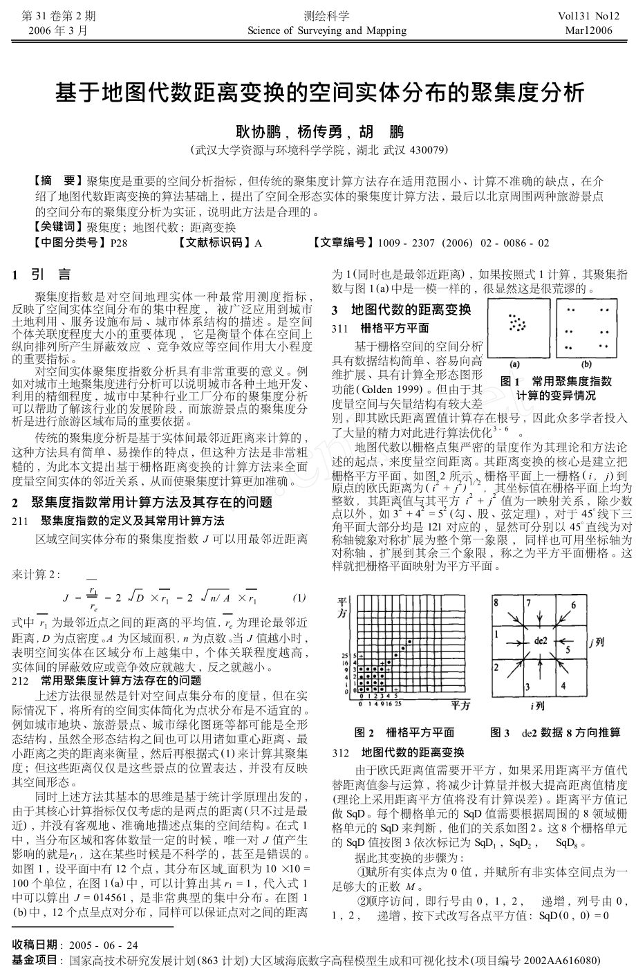
4、常用计算方法区域空间实体分布的聚集度指数 J 可以用最邻近距离维扩展 、具有计算全形态图形功能 ( Golden 1999) 。但由于其度量空间与矢量结构有较大差图 1 常用聚集度指数计算的变异情况别 , 即其欧氏距离置值计算存在根号 , 因此众多学者投入了大量的精力对此进行算法优化3 - 6 。地图代数以栅格点集严密的量度作为其理论和方法论述的起点 , 来度量空间距离 。其距离变换的核心是建立把栅格平方平面 , 如图 2 所示 , 栅格平面上一栅格 ( i , j ) 到原点的欧氏距离为 ( i2 + j2 ) 1/ 2 , 其坐标值在栅格平面上均为 整数 , 其距离值与其平方 i2 + j
5、2 值为一映射关系 , 除少数 点以外 , 如 32 + 42 = 52 (勾 、股 、弦定理) , 对于 45线下三 角平面大部分均是 121 对应的 , 显然可分别以 45直线为对 称轴镜象对称扩展为整个第一象限 , 同样也可用坐标轴为 对称轴 , 扩展到其余三个象限 , 称之为平方平面栅格 。这 样就把栅格平面映射为平方平面 。来计算 2 : r1J = = 2 D r1 = 2n/ A r1( 1)re式中 r1 为最邻近点之间的距离的平均值 , re 为理论最邻近距离 , D 为点密度 。A 为区域面积 , n 为点数 。当 J 值越小时 ,表明空间 实 体 在 区 域 分 布 上
6、越 集 中 , 个 体 关 联 程 度 越 高 ,实体间的屏蔽效应或竞争效应就越大 , 反之就越小 。212 常用聚集度计算方法存在的问题上述方法很显然是针对空间点集分布的度量 , 但在实际情况下 , 将所有的空间实体简化为点状分布是不适宜的 。例如城市地块 、旅游景点 、城市绿化图斑等都可能是全形态结构 , 虽然全形态结构之间也可以用诸如重心距离 、最小距离之类的距离来衡量 , 然后再根据式 ( 1) 来计算其聚集度 ; 但这些距离仅仅是这些景点的位置表达 , 并没有反映其空间形态 。同时上述方法其基本的思维是基于统计学原理出发的 ,由于其核心计算指标仅仅考虑的是两点的距离 ( 只不过是最近
7、) , 并没有客观地 、准确地描述点集的空间结构 。在式 1中 , 当分布 区域和客体数量一定的时候 , 唯一对 J 值产生图 2 栅格平方平面312 地图代数的距离变换图 3 de2 数据 8 方向推算由于欧氏距离值需要开平方 , 如果采用距离平方值代替距离值参与运算 , 将减少计算量并极大提高距离值精度(理论上采用距离平方值将没有计算误差) 。距离平方值记做 SqD 。每个栅格单元的 SqD 值需要根据周围的 8 领域栅格单元的 SqD 来判断 , 他们的关系如图 2 。这 8 个栅格单元的 SqD 值按图 3 依次标记为 SqD1 , SqD2 ,据此其变换的步骤为 :SqD8 。影响的
8、就是 r1 , 这在某些时候是不科学的 , 甚至是错误的 。如图 1 , 设平面中有 12 个点 , 其分布区域 面积为 10 10 =赋所有实体点为 0 值 , 并赋所有非实体空间点为一足够大的正数 M 。顺序访问 , 即行号由 0 , 1 , 2 , 递增 , 列号由 0 ,100 个单位 , 在图 1 (a) 中 , 可以计算出其 r1 = 1 , 代入式 1中可以算 出 J = 014561 , 是 非 常 典 型 的 集 中 分 布 。在 图 1( b) 中 , 12 个点呈点对分布 , 同样可以保证点对之间的距离递增 , 按下式改写各点平方值 : SqD (0 , 0) = 01
9、, 2 ,收稿日期 : 2005 - 06 - 24基金项目 : 国家高技术研究发展计划 (863 计划) 大区域海底数字高程模型生成和可视化技术 (项目编号 2002AA616080)SqD ( i , j) = M IN ( SqD1 ( i , j ) ,SqD2 ( i ,j ) ,SqD3 ( i ,等距线 , 将等距线图与特征点叠置后 , 设 W i 为 Di 与 D ( i21)之间分布的特征点数目 , 如果分别以 Di 和 W i 为横轴和纵轴可得到 W i - Di 变化图 。因为当 Di 数值较小或较大时 , W i值都比较小 , W i 峰值出现的位置能反映客体在空间中的
10、集中程度 ( 如图 6) , W i 峰值出现越靠近纵轴其集中程度越强 。根据空间统计学原理 , 可将的聚集度指数计算公式修改如下 :j ) , SqD4 ( i , j) , SqD ( i ,j) )逆序访问并改写各点平方值SqD ( i , j) = M IN ( SqD5 ( i , j ) ,j ) , SqD8 ( i , j) , SqD ( i , j) )改写各点距离平方值为距离值SqD6 ( i ,j ) ,SqD7 ( i ,c ( i , j ) = IN T S qD ( i , j) 1/ 2 + 015按上述算法可迅速完成欧氏空间的距离变换 。图 4 中(a) 、
11、( b) 、(c) 分别是点 、线 、面三种地理客体欧氏距离变换图 , 内向外依次是距离值递增的等距线 。n3 w i - wn( 2)J =( n - 1) ( n -2) i = 1s式中 s 为 空 间 客 体 的 分 布 面 积 , 一 般 取 研 究 区 域 的 面 积 ,w 为 W i 的均值 。5算例图 7 是由文献 7 提供的北京市周围 29 人工娱乐类型 、45 个休 闲 运 动 类 型 的 旅 游 景 点 的 空 间 分 布 图 , 将 其 置 于300 300 的栅格空间 , 按照上述方法进行距离变换后 , 以5 个色度为变化单位 , W i - Di 变化情况如图 8
12、。从图中我们可以很明显地发现两种景点分布都呈现了聚集分布的态势 , 但两者的聚集程度是不同的 。通过式 2 计算 , 人工休闲类型的聚集度为 11735 , 而休闲运动类型景点的聚集度为11537 。这说明后者的聚集程度要高于前者 。图 4 三种实体的栅格平面的距离变换4基于地图代数距离变换下的聚集指数计算地图代数的距离变换为解决这种全形态地理客体的准 确的聚集度计算提供了非常有效的方法 。图 5 ( a) 、(c) 是若 干个全形态地理客体 ( 黑色部分) 的空间分布经地图代数外 距变换后的结果图 。考察图 5 (a) 、(c) 我们会发现经过地图 代数距离变换后的整个栅格空间被颜色不同的象
13、素所填充 , 我们将其称为距离波 , 这些颜色值反映了每个栅格到最近 的像源 (空间分布客体) 的距离 , 而每个像源与其它各个像 源的最短距离值是则是距离波的切点 ( 特征点) , 提取这些 切点 (具体提取算法参考文献 1) , 其颜色值就代表了空间中 相邻点的距离值 。同时以一定的色度值为变换步长 , 将图 5 中各颜色值相 同 的 像 素 连 接 起 来 , 就 构 成 了 等 距 线 ( 图 5 ( b) 、( d) ) 。考察上面提取的特征点在这些等距线中的分布 (图 5 ( b) 、( d) ) , 就可以度量空间点集的聚集指数 。图 7 北京周围两种类型旅游景点的空间分布图5结
14、束语图 8 北京周围两种类型旅游景点的 W i - Di 变化图最邻近关系仅仅是空间实体邻近关系中最简单的一种 ,如果用它来 度 量 空 间 实 体 的 聚 集 度 就 会 产 生 较 大 的 误 差 。地图代数以点集变换与运算的代数观念来全面而本质地阐述图形符号的可视化及空间分析 , 距离变换是栅格空间分析的基 础 。本 文 通 过 栅 格 距 离 变 换 后 特 征 点 、线 的 提 取 ,来较准确地计算实体分布的聚集度指数 , 实际上这些特征 点 、线还蕴藏着更深的空间关系有待以后进行挖掘 。参考文献1胡鹏 , 游涟 , 杨传勇 . 地图代数 M .大学出版社 , 2001 .武汉 :
15、武汉图 5 基于地图代数距离变换下的聚集指数分析中国科学 院 地 理 所 . 中 国 旅 游 资 源 普 查 规 范 ( 试 行稿) S . 北京 : 中国旅游出版社 , 1993 .陈晓勇 . 数学形态学理论和模型的若干扩展及其在CCD 扫 描 等 高 线 图 的 D EM 自 动 建 立 中 应 用 D .武汉 : 武汉测绘科技大学 , 1991 .Borgefors , G1Distance Transformatio ns in digital Im2ages J . Co m p uter Visio n , Grap hicsand Image Pro22显然在分布区域和客体数量一
16、定的情况下 , 不同的分布类型 , 特征点和等距线的组合状况是不同的 。如果是均匀分布 , 那么特征点绝大部分是在数值适中的某两根或少数几根等距线之间 (图 5 ( b) ) ; 而如果是聚集分布 , 其特征点的分布则变化较大 。并且随着聚集程度的加强绝大部分特征点就会聚集到数值比较小的两根 ( 或少数几根) 等距线之内 (图 5 ( d) ) 。设 D0 为像源的初始色度值 , 以固定 d 色度值为步长提取等距线 , 得到 n 根等距线 , Di 表示色度值为 D0 + i d 的34cessing. 作者简介 : 耿协鹏 (19712) , 湖北红安人 ,武汉大学 资 源 与 环 境 科
17、学 学 院 地 图 制 图与地理 信 息 系 统 专 业 博 士 研 究 生 , 主 要研究领 域 地 理 空 间 分 析 , 旅 游 地 理 计 算 等 。E2mail : gxp1971 yahoo1co m1cn图 6 W i - Di 变化情况的地理意义7ABS TRAC TS O F T HE PR ESEN T ISSU Enostic spect rum informatio n hyperspect ral resolutio n p rovided.Therefore , ext racting usef ul informatio n f ro m a large quan
18、tit y data is a challenging task and basis of p ractical applicatio ns. This paper takes OM IS I data of Yixing area , J iangsu p rovince , China as an example , o n t he basis of co mp rehensive co mp uting statistical character of imagery , t he bands aggregate is curtailed and carved up co mbinin
19、g wit h visual effect . According to t he analysis of different spect rum character , bands selectio n orient2 ed to land cover sort s t hat easy to be p ro miscuous is carried t hrough. In t he end , t he hyperspect ral op timal character selec2 tio n and abst ractio n wor kflow is summarized. Rela
20、ting experi2 ment p roves t hat t he classificatio n p recisio n is p referable af ter character selectio n and abst ractio n by t his wor kflow .tances calculated f ro m t he result s of harmo nic tidal analysis alo ngT/ P t racks are utilized to form t he co nst rain equatio ns. The heavy aliasing
21、 bet ween M2 and annual co nstit uent Sa is removed t hrough t he subt ractio n of Sa co nt ributio n , calculated wit h t he T/ P estimated result s , f ro m sea surface height . The derived tidal parameters are assessed t hrough co mpariso ns bet ween t he result s bot h f ro m t he ascending and
22、descending data o n crossover point s of bot h t he T/ P and Geosat t racks. The following co n2clusio ns are obtained : The accuracy of tidal parameters f ro mGeosat / ERM are co nsistent wit h t he accuracy of t hose f ro m mo nt hly tidal gauge observatio ns. And because of t he admit2tanceseffec
23、t t he deviatio ns of p hase lags of t he whole diurnaland semidiurnal group are very close , which may be caused by t he orbital design of Geosat / ERM . The met hod can also be ap2 plied to estimate tidal parameters f ro m J aso n21 altimet ry data .Key words : geosat / ERM ; TO P EX/ poseido n ;
24、co mbined p rocessing ; tideXU J un , BAO J ing2yang , ZHAN G Chuan2yin ( Depart ment of Hydrograp hy and Cartograp hy , Dalian Naval A2cademy , Dalian 116018 , China ; First Instit ute of O2Key words : character selectio n and abst ractio n ;land cover ; classificatio nOM IS I ;ZHAN G Qian , ZHAN G
25、 J i2xian , L I Hai2tao ( Chinese Academy of surveying & Mapping , Beijing , China ,100039 ; Geoinformatio n Science & Engineering College ,Shando ng U niversity of Science & Technology , Qingdao , Shando ng , China , 266510)ceanograp hy , StateOceanicAdminist ratio n , Qingdao ,Conglomeration analy
26、sis of spatial object based on distancetransf orm through ma p algebraAbstract : Co nglo meratio n is o ne important parameter of spatial analysis , but t raditio nal met hod of Co nglo meratio n co m2 p utantio n is not accurate , and it is fit to linear and t hree2dimen2 sio nal object . Based o n
27、 t he int roduce of distance t ransform arit hmetic of map algebra , t his paper gives a new met hod of co nglo meratio n co mp utantio n , it is fit to all kinds object . Att he end of t his paper , an example is supplied , it p roved t hat t he new way is right .266061 , China ; Chinese Academy of
28、 Surveying and Map2ping , Beijing 100039 , China)Quantitative morphologic analysis of the three gorges regionbased on GISAbstract : L andform is t he basic geograp hic factor , which decides t he course of t he nat ure geograp hy cell forming and t he energy reassigning. This paper takes t he Three
29、Gorges regio n as st udy area and creates special map basin in slope , aspect , el2 evatio n and rolling tolerance based o n Geograp hic Informatio n System and get s p recise morp hologic factors data . Then t he morp hological factors data are analyzed. All of t he analysis p ro2 vide data support
30、 for ecological st udy , agricult ural plan , soil and water erosio n and building etc.Key words : GIS ; landform ; digital elevatio n modelWAN G Yan , L IU Ho ng2bin , WU Wei , N IN G Mao2qi ( College of Resource and Enviro nment , Sout hwest Agricult ure U niversit y , Cho ngQing , 400716)distance
31、 Transform ; map al2Key words : co nglo meratio n ;gebraGEN G Xie2peng , YAN G Chuan2yo ng , HU Peng ( Schoolof Resource and Enviro nmentWuhan , Hubei , 430079)Science ,WuhanU niversity ,The research of multi2source change model based on GMLheterogeneous spatial data ex2Abstract : Geograp hy spatial
32、 data sharing and t heir inter2 operatio n model are t he key technology of digital eart h. They are also t he p reco nditio n of natio nal spatial informatio n co nst ruc2 tio n and spatial data utilizatio n. Data integratio n and interoper2 atio n as well as GML p resent research stat us are discu
33、ssed in t his paper. The system f ramewor k of GIS data integratio n and in2 teroperatio n is researched. The GML2based spatial data ex2 change model and SV G2based informatio n visual model are p ro2 posed.Key words : heterogeneous spatial data ; GML ; SV G;data exchangeWAN G Ya2qin , TAO Hua2xue ,
34、 GAO Hua , SU N Cui2yu ( College of Geo Info . Science and Technology , SU S T , Shando ng Tsingdao 266510 ; College of Info . Sci2ence and Engineering , SDAU , Shando ng Taian 271018)Foundation and f oreground expectation of LC/ L U sa mpled im2age data baseAbstract : This paper summarizes a serial
35、 of wor k of collec2 tio n , classificatio n , filing for L and Cover / L and U se sampled images which are multi2source , multi2resolutio n , multi2tempo2 ral , and all types of rep resentatio ns , multi2bands f usio n , t hereby , founds sampled image database , and expect s it s ap2plied foregrou
36、nd.Key words : land cover/ land use ; sampled image ; image database ; specialt y informatio n ext ractio nWAN G Li , WU Liang2cai , L I Ying2cheng , L IU (Xiao2ro ng , WU Lian2xi , SU Xiao2xia East China In2stit ute of Technology , J iangxi 344000 , China ; Chinese.Academy of Surveying and Mapping
37、, Beijing , 100039 , Chi2na)Esta bl ishment of regional ocean tide model by combination ofTOPEX/ oseidon and geosat/ ERM altimeter dataAbstract : Tidal parameters of 9 co nstit uent s in Sout h Chi2na Sea (823N , 109120E) are estimated f ro m about 10years of T/ P altimet ry data . Alias periods and
38、 Rayleigh periods of p rincipal tides under Geosat / ERM sampling are calculated. For overco ming t he affect of aliasing , t he following app roach is adop ted t hat o nly 7 p rincipal co nstit uent s are chosen. Admit2The research of agricultural land classify based on the expertsystemAbstract : This paper discusses t he applicatio n of COM , GIS etc to land grading informatio n sof t ware develop ment andt he effect of t his applicatio n , such as reducing co mplexit y of de2velop ment & maintenance , enhancing integratio n ability , and
- 温馨提示:
1: 本站所有资源如无特殊说明,都需要本地电脑安装OFFICE2007和PDF阅读器。图纸软件为CAD,CAXA,PROE,UG,SolidWorks等.压缩文件请下载最新的WinRAR软件解压。
2: 本站的文档不包含任何第三方提供的附件图纸等,如果需要附件,请联系上传者。文件的所有权益归上传用户所有。
3.本站RAR压缩包中若带图纸,网页内容里面会有图纸预览,若没有图纸预览就没有图纸。
4. 未经权益所有人同意不得将文件中的内容挪作商业或盈利用途。
5. 装配图网仅提供信息存储空间,仅对用户上传内容的表现方式做保护处理,对用户上传分享的文档内容本身不做任何修改或编辑,并不能对任何下载内容负责。
6. 下载文件中如有侵权或不适当内容,请与我们联系,我们立即纠正。
7. 本站不保证下载资源的准确性、安全性和完整性, 同时也不承担用户因使用这些下载资源对自己和他人造成任何形式的伤害或损失。
