 Streams and Rivers.

《Streams and Rivers.》由会员分享,可在线阅读,更多相关《Streams and Rivers.(29页珍藏版)》请在装配图网上搜索。
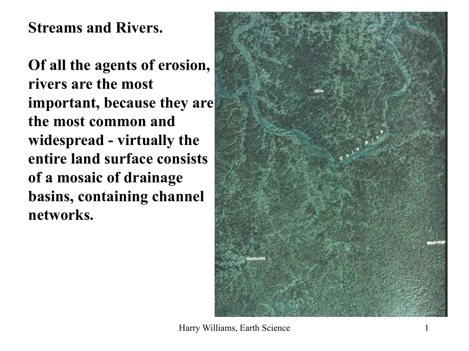
1、Harry Williams, Earth Science1Streams and Rivers.Of all the agents of erosion, rivers are the most important, because they are the most common and widespread - virtually the entire land surface consists of a mosaic of drainage basins, containing channel networks.Harry Williams, Earth Science2A drain
2、age basin is an area that drains into a channel network, delimited by a DRAINAGE DIVIDE. Rivers erode landscapes by carrying away sediment supplied by mass wasting or eroded from slopes by water running over the surface. This causes SHEETFLOW, RILLS and GULLIES.Chris 14.4Harry Williams, Earth Scienc
3、e3Rills formed from concentrated sheetflow (left); further surface flow concentration results in gullies (below). Cultivation of the field promoted surface runoffHarry Williams, Earth Science4Sediment TransportOnce the water enters the channel system, it becomes concentrated and its ability to trans
4、port sediment increases. Sediment is supplied from surrounding hill slopes and/or erosion of the streams own banks and bed. Scour and fill.Harry Williams, Earth Science5The amount of sediment transported depends mainly on the volume of flow; this is of course related to the size of the drainage basi
5、n and will fluctuate according to inputs of precipitation. The volume of streamflow, or discharge, is measured in cubic meters (or feet) per second. A graph showing the fluctuation in discharge through time is a HYDROGRAPH. Harry Williams, Earth Science6The largest particle transported depends on th
6、e velocity of flow; the greater the velocity the more turbulent the flow becomes and the greater the lift forces; generally speaking, higher velocities are found at greater discharges and on steeper slopes. Sediment is entrained at its entrainment velocity and then transported until the velocity fal
7、ls below its settling velocity, when deposition occurs - these vary according to size (weight) of sediment.Flow width, depth & velocity all increase with discharge, which increases downstream or following rain.Harry Williams, Earth Science7MODES OF SEDIMENT TRANSPORTGenerally, 3 main sediment transp
8、ort modes are recognized:1. Solution load - dissolved rock carried in the flow.2. Suspended load - finer sediment (usually clay and silt) suspended by turbulence in the flow (does not contact bed).3. Bed load - coarser sediment (sand + gravel) that slides, rolls or skips along the stream bed.Harry W
9、illiams, Earth Science8Example: Mississippi Sediment Loads1. SOLUTION (200 million tons/year)2. SUSPENSION (500 million tons/year)3. BED LOAD (50 million tons/year)Harry Williams, Earth Science9If the river slows down, for example as its gradient decreases downstream, or by entering the sea, then DE
10、POSITION occurs forming an ALLUVIAL DEPOSIT (Alluvium = river sediment).The photo here is a special case of alluvial deposition - a braided river. This river drains meltwater from glaciers and is choked with sediment that it cant transport - multiple alluvial bars result.Harry Williams, Earth Scienc
11、e10River ValleysGenerally speaking, it is true that river valleys in upper reaches tend to be narrow and steep, while in lower reaches valleys are wider and have more gentle slopes. The steeper slopes in upper reaches promote vertical and headward erosion, rather than lateral erosion. Harry Williams
12、, Earth Science11In lower reaches, 2 important changes usually occur - the river becomes an alluvial channel (begins to flow through its own alluvium); and the channel has a greater tendency to erode laterally, leading to a wider, flat bottomed valley, filled with a layer of alluvium.Upper reachesLo
13、wer reachesHarry Williams, Earth Science12Most rivers are MEANDERING - for the most part a single channel that twists from side to side across the valley floor. Meandering rivers also have the ability to migrate from side to side and so cause lateral erosion of the valley walls.Harry Williams, Earth
14、 Science13Since flow is faster around the outside of a bend, meanders tend to shift sideways by eroding their outer bank (higher flow entrainment) forming a cutbank and at the same time depositing sediment on their inner bank forming point bars (lower flow - deposition). Harry Williams, Earth Scienc
15、e14Harry Williams, Earth Science15Harry Williams, Earth Science16The resulting plain is the FLOODPLAIN (because it is covered by floods). Floodplains are built from point bar deposits and flood deposits. BedrockHarry Williams, Earth Science17NATURAL LEVEES - during floods, as the flow overflows the
16、channel and enters the floodplain, it slows down and much of the sediment load (especially coarser, heavier sediment) is deposited on the channel banks; this forms ridges running parallel to the channel. Harry Williams, Earth Science18There are also artificial levees, built to hold back flood waters
17、 - although they can fail to do so. A levee breaks in the 1993 midwest floods (Monroe county, Illinois).Harry Williams, Earth Science19OXBOW LAKES - sometimes meanders tighten and form cutoffs; the abandoned meander forms an oxbow lake. These lakes eventually fill with sediment/vegetation, becoming
18、meander scars.A recent cutoff and the beginning of an oxbow lake.Harry Williams, Earth Science20Harry Williams, Earth Science21Case study: Denton Creek.Denton Creek drains portions of Montague, Wise and Denton counties in north-central Texas. Clastic sediment sources in the drainage basin include ri
19、lls, gullies and channel bank and bed erosion. Sediment eroded from the drainage basin is deposited into Grapevine Lake which was created in 1952 by damming Denton Creek. Harry Williams, Earth Science22Drainage basin of Denton Creek (bold black line). Numbers 1-7 refer to field trip sites described
20、below. Blue dashed line separates sandstone bedrock underlying the northern portion of the drainage basin from limestone bedrocks underlying the southern portion. Yellow and orange colors indicate stream floodplain deposits.Harry Williams, Earth Science23Site 1. Gullies and Rills on a Sandstone Hill
21、side. The combination of heavy rain (for example during spring thunderstorms) and sandy ground with low permeability causes surface run-off and erosion in the northern portion of the drainage basin. The erosion creates large gullies and smaller rills.Harry Williams, Earth Science24Sites 2 & 3. Strea
22、m Bank and Bed Erosion in an area of Limestone Bedrock. Limestone bedrocks in the drainage basin produce dark clayey soils. The steep banks of small streams atsites 2 & 3 are evidence of bank erosion.Harry Williams, Earth Science25Site 4. Large Gullies on Sandstone Bedrock. Some gullies have grown p
23、articularly large in the northern portion of the drainage basin. In some cases multiple gullies form branches of large system of gullies.Gully systemSingle branchHarry Williams, Earth Science26Site 5. Denton Creek on Sandstone Bedrock. The small streams, rills and gullies all feed into Denton Creek
24、- the main stream of the drainage basin. The channel has steep sandy banks and a flat sandy bed. The steep banks are evidence of ongoing bank erosion (during high stream flows). The flat grassy area in the distance is the creeks floodplain, constructed from sandy stream sediment (alluvium) eroded fr
25、om upstream (including the gullied area at site 4). This floodplain is one of the areas shown in yellow on Fig. 1.Harry Williams, Earth Science27Site 6. Denton Creek on Limestone Bedrock. Although Denton Creek is underlain by limestone bedrock at site 6, the channel still has steep sandy banks and a
26、 flat sandy bed because it is an alluvial channel - the creek runs through its own deposits of sand transported from the northern portion of the drainage basin.Harry Williams, Earth Science28A small earthflow caused by recent heavy rain on the bank of the creek at site 6. This, and the fallen tree j
27、ust above the earthflow, is evidence of ongoing bank erosion.Harry Williams, Earth Science29Denton Creek at the head of Grapevine Lake appears much the same as in other parts of the drainage basin - steep sandy banks and a flat sandy bed (Fig. 12). As at site 6, the creek is running through its own deposits of sandy sediment.
- 温馨提示:
1: 本站所有资源如无特殊说明,都需要本地电脑安装OFFICE2007和PDF阅读器。图纸软件为CAD,CAXA,PROE,UG,SolidWorks等.压缩文件请下载最新的WinRAR软件解压。
2: 本站的文档不包含任何第三方提供的附件图纸等,如果需要附件,请联系上传者。文件的所有权益归上传用户所有。
3.本站RAR压缩包中若带图纸,网页内容里面会有图纸预览,若没有图纸预览就没有图纸。
4. 未经权益所有人同意不得将文件中的内容挪作商业或盈利用途。
5. 装配图网仅提供信息存储空间,仅对用户上传内容的表现方式做保护处理,对用户上传分享的文档内容本身不做任何修改或编辑,并不能对任何下载内容负责。
6. 下载文件中如有侵权或不适当内容,请与我们联系,我们立即纠正。
7. 本站不保证下载资源的准确性、安全性和完整性, 同时也不承担用户因使用这些下载资源对自己和他人造成任何形式的伤害或损失。
